NZAIA
  • Home
    • Environmental Impact Assessment
    • Social Impact Assessment
    • Strategic Environmental Assessment
    • Community & Stakeholder Engagement
    • Management, Monitoring and Reporting
  • About Us
    • Core Group >
      • Core Group Meeting Minutes
    • Our Partners and Affiliates
    • AGMs
    • Ethics
  • Membership
    • Sign Up for NZAIA Membership
  • Conferences
    • Proceedings from Past Conferences >
      • 2022 - Wellbeing, Sustainability and Impact Assessment: towards more integrated policy-making
      • 2021 - Social Impact Assessment >
        • Posters
        • 2021 Students
      • 2019 - Climate Change >
        • Posters
        • 2019 Students
        • Conference Photos
        • Contact List
      • 2018 - Regional Development
      • 2016 - Strategic Environmental Assessment
      • 2015 - Where to for Impact Assessment?
      • 2014 - Transport Infrastructure
      • 2013 Fresh Water Management
      • 2012 - Mineral Extraction
  • Impact Connector
    • Issue #14 Impact assessment for infrastructure development >
      • Impact assessment for infrastructure development - an introduction
      • Place Matters: The importance of geographic assessment of areas of influence in understanding the social effects of large-scale transport investment in Wellington
      • Unplanned Consequences? New Zealand's experiment with urban (un)planning and infrastructure implications
      • Reflections on infrastructure, Town and Country planning and intimations of SIA in the late 1970s and early 1980s
      • SIA guidance for infrastructure and economic development projects
      • Scoping in impact assessments for infrastructure projects: Reflections on South African experiences
      • Impact Assessment for Pacific Island Infrastructure
    • Issue #13 Health impact assessment: practice issues >
      • Introduction to health impact assessment: practice issues
      • International Health Impact Assessment – a personal view
      • Use of Health Impact Assessment to develop climate change adaptation plans for health
      • An integrated approach to assessing health impacts
      • Assessing the health and social impacts of transport policies and projects
      • Whither HIA in New Zealand….or just wither?
    • Issue #12 Risk Assessment: Case Studies and Approaches >
      • Introduction
      • Risk Assessment and Impact Assessment : A perspective from Victoria, Australia
      • The New and Adaptive Paradigm Needed to Manage Rising Coastal Risks
      • Reflections on Using Risk Assessments in Understanding Climate Change Adaptation Needs in Te Taitokerau Northland
      • Values-Based Impact Assessment and Emergency Management
      • Certainty about Communicating Uncertainty: Assessment of Flood Loss and Damage
      • Improving Understanding of Rockfall Geohazard Risk in New Zealand
      • Normalised New Zealand Natural Disaster Insurance Losses: 1968-2019
      • Houston, We Have a Problem - Seamless Integration of Weather and Climate Forecast for Community Resilience
      • Innovating with Online Data to Understand Risk and Impact in a Data Poor Environment
    • Impact Connector #11 Climate Change Mitigation, Adaptation, and Impact Assessment: views from the Pacific >
      • Introduction
      • Climate change adaptation and mitigation, impact assessment, and decision-making: a Pacific perspective
      • Climate adaptation and impact assessment in the Pacific: overview of SPREP-sponsored presentations
      • Land and Sea: Integrated Assessment of the Temaiku Land and Urban Development Project in Kiribati
      • Strategic Environmental Assessment: Rising to the SDG Challenge
      • Coastal Engineering for Climate Change Resilience in Eastern Tongatapu, Tonga
      • Climate-induced Migration in the Pacific: The Role of New Zealand
    • Impact Connector #10 Climate Change Mitigation and Adaptation >
      • Introduction
      • Is a “just transition” possible for Māori?
      • Adapting to Climate Change on Scale: Addressing the Challenge and Understanding the Impacts of Asia Mega-Cities
      • How responding to climate change might affect health, for better or for worse
      • Kanuka, Kereru and carbon capture - Assessing the effects of a programme taking a fresh look at the hill and high country land resource
      • Wairoa: Community perceptions of increased afforestation
      • Te Kākahu Kahukura Ecological Restoration project: A story within a story
    • Issue #9 Impacts of Covid-19 >
      • Introduction to Impact Connector Issue 9 – Impact assessment and Covid 19
      • Covid-19 fast-track consenting: climate change legacy key to success
      • Tourism – the long haul ahead
      • Making sense of the impact of Covid-19: planning, politics, and the public good
    • Issue #8 Social Impact Assessment >
      • Challenges for Social Impact Assessment in New Zealand: looking backwards and looking forwards
      • Insights from the eighties: early Social Impact Assessment reports on rural community dynamics
      • Impact Assessment and the Capitals Framework: A Systems-based Approach to Understanding and Evaluating Wellbeing
      • Building resilience in Rural Communities – a focus on mobile population groups
      • Assessing the Impacts of a New Cycle Trail: A Fieldnote
      • The challenges of a new biodiversity strategy for social impact assessment (SIA)
      • “Say goodbye to traffic”? The role of SIA in establishing whether ‘air taxis’ are the logical next step in the evolution of transportation
    • Issue #7 Ecological Impact Assessment >
      • The future of Ecological Impact Assessment in New Zealand
      • Ecological impact assessment and roading projects
      • EcIA and the Resource Management Act
      • Professional Practice and implementation of EcIA
      • EcIA in the Marine Environment
    • Issue #6 Landscape Assessment >
      • Introduction
      • Lives and landscapes: who cares, what about, and does it matter?
      • Regional Landscape Inconsistency
      • Landscape management in the new world order
      • Landscape assessment and the Environment Court
      • Natural character assessments and provisions in a coastal environment
      • The Assessment and Management of Amenity
      • The rise of the THIMBY
      • Landscape - Is there a common understanding of the Common?
    • Issue #5 Cultural Impact Assessment >
      • Introduction
      • Potential of Cultural Impact Assessment
      • The Mitigation Dilemma
      • CIA and decision-making
      • Insights and observations on CIA
      • Achieving sustainability through CIA
      • CIA - Enhancing or diminishing mauri?
      • Strategic Indigenous Impact Assessment?
    • Issue #4 Marine Environment >
      • Introduction
      • Iwi, Impact Assessment and Marine Environment
      • Sea-Bed Mining Application in Taranaki
      • The wreck of the MV Rena
      • High Court RMA Controls on Fishing
      • Initiatives in the Pacific Islands
      • SEA in an NZ context
    • Issue #3 Strategic Environmental Assessment
    • Issue #2
    • Issue #1
  • Resources
    • Webinars
    • IAIA Resources
    • United Nations Guidance
    • Donors Guidelines and Principles
    • Oceania and the Pacific
    • Natural Systems >
      • Biodiversity & Ecosystem Services
      • Agriculture & Food Systems
      • Water Management
    • Social Impact Assessment
    • Health Impact Assessment >
      • Climate Change & Health
      • Air Quality Impact Assessment
    • Cumulative Impact Assessment
    • Community and Stakeholder Engagement
    • Indigenous Peoples
    • Climate Change and Disaster Risk Resilience >
      • Adaptation Planning
      • Nature-based Solutions
    • Urban Development
    • Sustainable Development Goals
    • Strategic Environmental Assessment
  • Community
    • Membership Directory
    • News
    • Policy Submissions >
      • Past Submissions
    • Courses

Improving Understanding of Rockfall Geohazard Risk in New Zealand

John Kreft & Mark Easton 

WSP New Zealand

1  Geohazard Risk in New Zealand

​The presence of geological hazards, such as discrete rockfall events and large-scale slope failures, is well known and nothing new to Aotearoa. The extreme topography and climatic range of both Te Ika-a-Māui and Te Waipounamu results in transportation corridors that have to navigate challenging terrain, resulting in infrastructure and users often being subject to geohazards.
 
This is a short paper highlighting the importance of utilising greater extents of readily available data to inform on the Life Safety risk posed by geohazards to the users of highway networks in New Zealand, with the end goal of reducing their impacts in a cost-effective and sustainable manner. It also provides an overview of how continuously consumable and relevant data can be used to automatically provide indicative risk estimates, at scale.

2  The Kaikōura Earthquake 

The 7.8 Mw Kaikōura earthquake of 14 November 2016 resulted in ~10,000 landslides which closed State Highway 1 (SH1) along the Kaikōura coastline between Oaro and Clarence. The Main North Line railway was also closed due to landslides and damage to rail infrastructure. In response, the North Canterbury Transport Infrastructure Recovery (NCTIR) alliance was established between Waka Kotahi NZ Transport Agency (Waka Kotahi) and KiwiRail, successfully restoring and upgrading these vital transport links over a few short years.

3  Change Catalyst for Approach to Risk Management 

​When NCTIR operations in Kaikōura mostly ended in March Waka Kotahi were left with a large inventory of geohazards and geotechnical structures to manage and maintain. The ‘continued and optimal performance of these GeoAssets are recognised by both Waka Kotahi and KiwiRail to be critical in the provision of a safe and resilient transport corridor’ (Easton 2021). Rockfall and landslide events are still occurring along the corridor due to the evolving hillside condition and vegetation cover, post-earthquake. 
Figure 1 shows the aftermath of a rock impacting a moving vehicle in 2019, highlighting the levels of risk that still exist along the corridor which Waka Kotahi, as a road controlling authority, has a duty of care to manage. As such, there was a need to shift focus away from recovery and transition to a holistic network life safety risk management approach. 
Picture
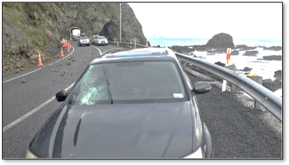
Figure 1 - Aftermath of discrete block impacting moving vehicle south of Kaikōura

4  Estimation of Risk

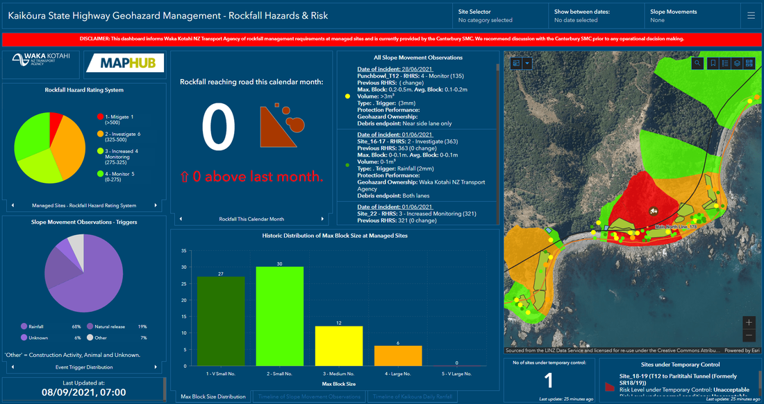
​Risk is no arbitrary concept, rather a measure and is best estimated using sound data. One of the many successes of the NCTIR alliance has been the variety and volume of data collected. Figure 2 shows at a large scale, the concentration of 1,000+ slope movements recorded between 2017-2020. This simple visual draws the reader’s attention to the hotspot of incidents and gives an indication of where there are potential problems needing to be addressed. 

​However, risk is simply not defined by a slope’s ability to yield rockfall debris, i.e presence of the hazard. To fully understand the risk to the road user from these geohazards, the attributed data within these events (magnitude, frequency) have to be interrogated and integrated with other available data including the traffic volume, vehicle speeds and the geological variables of the yielding slopes.  
Picture
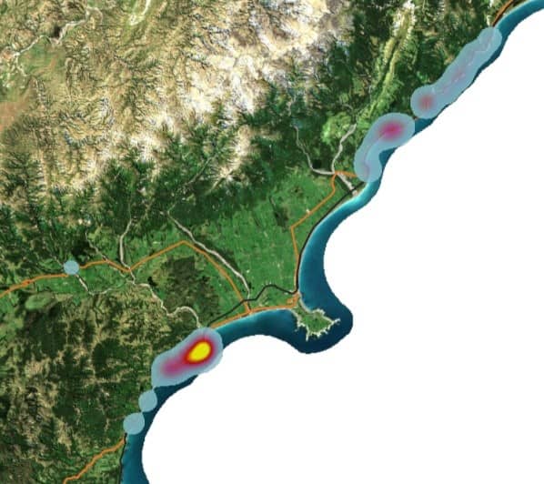
Figure 2 - GIS visualisation of Slope Movements observed in Kaikōura
The combination of these data provides metrics including:

  • Probability – the extent to which something is likely to happen (a slope failure and reaching element at risk), usually expressed as a number between 0 and 1.
  • Likelihood – derived from the probability of rockfall detachment (Pd) and the likelihood of the rockfall reaching the element at risk (Pt).
  • Temporal – the time spent in the path of a rockfall by the element at risk.
  • Vulnerability – the level of potential harm from a geohazard event (e.g. death or serious injury).
  • Consequence – the outcome of an event, often expressed qualitatively as criticality.

​With strong datasets, each of these variables can be associated with statistically valid numerical values and therefore the outputs can be quantitative in nature providing actual rather than relative estimation of risk (Figure 3).  
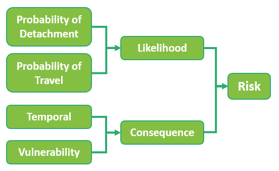
Figure 3 - Flow diagram of rockfall risk estimation
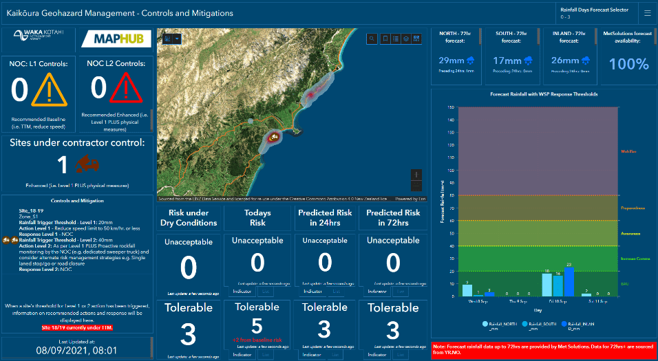
The assessment of risk for any given geohazard requires an experienced practitioner who focuses on detailed capture and documentation of each hazard. Traditionally this process can be very time and resource-hungry typically, making a full qualitative risk assessment an exception, not a norm. 

Given ​the number of known geohazards continuing to develop along the Kaikōura coastline, a more efficient approach to estimate and triage all risks across the corridor was necessary.  

5  Automating Slope Failure Risk Estimation At Scale 

​Due to the volume of data, variance in formats, wide range of sources and the varying levels of completeness, a novel approach innovated collaboratively by WSP and Waka Kotahi, was developed.
 
The processing is undertaken automatically using industry standard data manipulation software, Feature Manipulation Engine (FME). FME is an ‘Extract, Transform, Load’ (ETL) platform which streamlines the translation of spatial and textual data. It was chosen as the platform for this project due to its ability to connect to Application Programming Interfaces (API) to consume data from online sources instantaneously, translate and combine these data in a controlled way and publish new information to online endpoints. The built system in FME uses a likelihood and consequence product rule approach (NSW RMS 2014) as described earlier, together with geological scale event return period frequencies (e.g. order of magnitude), to robustly and consistently assess risk posed by geohazards.
 
By the automation of the NSW RMS 2014 approach, driven by in-field data capture,, FME and supplementary APIs provisionally estimates risk at scale for hundreds of sites in near real-time and a fraction of the time taken to physically do so. Given the number of geohazards assessed, this provides Waka Kotahi the ability to triage those carrying the highest risk to road users and prioritise detailed geotechnical inspections. 

6  Visualising Estimated Slope Failure Risk

It is important that the estimation of risk is not perceived to be a ‘black box’ approach where risk impact practitioners are unaware of the process and not therefore fully understanding of the outcomes. To avoid this and to provide a fully transparent solution, this system frequently updates online GIS repositories and databases which drive a series of informative dashboards displaying the following:
​
  • The current risk of any known geohazard (Figure 4), given historical activity, to inform long-term mitigation strategies, such as installing geotechnical structures where necessary. Information included: location and magnitude distribution of historical slope movements with photographs and monthly performance of geohazards.
  • Status and condition of existing geotechnical structures to ensure risk to road users is kept to a minimum.
  • Short-term changes in risk due to forecast meteorological conditions such as rainfall, high winds, freeze/thaw (Figure 5).
 
These interactive dashboards have given risk impact practitioners, responsible for the safety of New Zealand’s state highways, a vehicle to own and drive risk mitigation strategies.
Figure 4 - Estimation of current rockfall risk - Waka Kotahi MapHub dashboard
Figure 4 - Estimation of current rockfall risk
​Whilst understanding long-term baseline risk is key in defining mitigation strategies, it is also as important to consider the immediate and short-term risk form geohazards to road users due to forecast meteorological conditions. From a quantitative perspective, rockfalls occur mainly during, or shortly after, periods of intense precipitations. The collected data in Kaikōura puts the percentage of rockfall events due to rainfall or wind at 79%.
Figure 5 - Predicted changes in risk due to forecast meteorological conditions - Waka Kotahi Maphub dashboard
Figure 5 - Predicted changes in risk due to forecast meteorological conditions
​Using observed rockfall events (collected in a standardised format with magnitude information) and pairing with meteorological conditions (e.g. recorded rainfall depth or wind speed) on the day of occurrence, enables a probability of future rockfall at particular rainfall intensities or wind speeds, to be estimated. This is a proactive approach to short-term risk management where risk practitioners can make decisions to enact temporary mitigation (e.g. moving the element at risk away from the hazard through a lane drop or closing the road) at sites where risk to the road user is predicted to increase to an unacceptable level.
 
Ultimately, this allows the relevant authorities to proactively manage the evolving risks posed by geohazards to road users at acceptable or tolerable levels, whilst at the same time undertake longer-term assessments to either invest in permanent mitigation or consolidate the current approach (e.g. addition of instrumentation and smart technology).

7  The road ahead 

​The presence of geohazards along lifelines such as the mountainous transport corridors of New Zealand is well known. The risk of geohazards to the road users is likely to increase given the continued evolution of slopes and hillsides capable of producing a failure, together with the projected increase in traffic volume.  Therefore, the understanding of risk and what it means for lifelines such as transportation corridors is more important than ever.
 
Building a geohazard management system capable of rapidly estimating life safety risk to road users, effectively managing geotechnical structures and using meteorological forecasts to predict short-term changes in risk levels, is achievable. Starting off at a local scale, with a wealth of great quality data as demonstrated with Kaikōura, is an effective way of highlighting the benefits of good data collection in a standardised format which has enabled the growth into a system which the roading authority now uses to make timely operational decisions.
 
This paper has provided an overview of what has been achieved so far using this data and how the geohazard management system it drives, provides a near-real time indication of risk estimation. Ultimately this system helps Waka Kotahi to conform to its policy of providing a safer and more resilient road network, ensuring available funds are proportionally invested where the greatest returns are realised.
Download as a PDF

References 

Easton, M. (2021). Comparison of the Rockfall Hazard Rating System versus the New South Wales Roads and Maritime Services Guide to Slope Risk Analysis (2014) for rockfall Life Safety risk management.
 
Easton, M. (2021). Integration of GeoHazard Management Plan: additional hazards and metrics
NSW RMS (2014). Guide to Slope Risk Analysis. Version 4. New South Wales Government, Roads and Maritime Services.
CONTACT US
​NZAIA Incorporated is a registered charity 
#CC54658
This website and all its content is SSL Protected. 
Privacy Policy

  • Home
    • Environmental Impact Assessment
    • Social Impact Assessment
    • Strategic Environmental Assessment
    • Community & Stakeholder Engagement
    • Management, Monitoring and Reporting
  • About Us
    • Core Group >
      • Core Group Meeting Minutes
    • Our Partners and Affiliates
    • AGMs
    • Ethics
  • Membership
    • Sign Up for NZAIA Membership
  • Conferences
    • Proceedings from Past Conferences >
      • 2022 - Wellbeing, Sustainability and Impact Assessment: towards more integrated policy-making
      • 2021 - Social Impact Assessment >
        • Posters
        • 2021 Students
      • 2019 - Climate Change >
        • Posters
        • 2019 Students
        • Conference Photos
        • Contact List
      • 2018 - Regional Development
      • 2016 - Strategic Environmental Assessment
      • 2015 - Where to for Impact Assessment?
      • 2014 - Transport Infrastructure
      • 2013 Fresh Water Management
      • 2012 - Mineral Extraction
  • Impact Connector
    • Issue #14 Impact assessment for infrastructure development >
      • Impact assessment for infrastructure development - an introduction
      • Place Matters: The importance of geographic assessment of areas of influence in understanding the social effects of large-scale transport investment in Wellington
      • Unplanned Consequences? New Zealand's experiment with urban (un)planning and infrastructure implications
      • Reflections on infrastructure, Town and Country planning and intimations of SIA in the late 1970s and early 1980s
      • SIA guidance for infrastructure and economic development projects
      • Scoping in impact assessments for infrastructure projects: Reflections on South African experiences
      • Impact Assessment for Pacific Island Infrastructure
    • Issue #13 Health impact assessment: practice issues >
      • Introduction to health impact assessment: practice issues
      • International Health Impact Assessment – a personal view
      • Use of Health Impact Assessment to develop climate change adaptation plans for health
      • An integrated approach to assessing health impacts
      • Assessing the health and social impacts of transport policies and projects
      • Whither HIA in New Zealand….or just wither?
    • Issue #12 Risk Assessment: Case Studies and Approaches >
      • Introduction
      • Risk Assessment and Impact Assessment : A perspective from Victoria, Australia
      • The New and Adaptive Paradigm Needed to Manage Rising Coastal Risks
      • Reflections on Using Risk Assessments in Understanding Climate Change Adaptation Needs in Te Taitokerau Northland
      • Values-Based Impact Assessment and Emergency Management
      • Certainty about Communicating Uncertainty: Assessment of Flood Loss and Damage
      • Improving Understanding of Rockfall Geohazard Risk in New Zealand
      • Normalised New Zealand Natural Disaster Insurance Losses: 1968-2019
      • Houston, We Have a Problem - Seamless Integration of Weather and Climate Forecast for Community Resilience
      • Innovating with Online Data to Understand Risk and Impact in a Data Poor Environment
    • Impact Connector #11 Climate Change Mitigation, Adaptation, and Impact Assessment: views from the Pacific >
      • Introduction
      • Climate change adaptation and mitigation, impact assessment, and decision-making: a Pacific perspective
      • Climate adaptation and impact assessment in the Pacific: overview of SPREP-sponsored presentations
      • Land and Sea: Integrated Assessment of the Temaiku Land and Urban Development Project in Kiribati
      • Strategic Environmental Assessment: Rising to the SDG Challenge
      • Coastal Engineering for Climate Change Resilience in Eastern Tongatapu, Tonga
      • Climate-induced Migration in the Pacific: The Role of New Zealand
    • Impact Connector #10 Climate Change Mitigation and Adaptation >
      • Introduction
      • Is a “just transition” possible for Māori?
      • Adapting to Climate Change on Scale: Addressing the Challenge and Understanding the Impacts of Asia Mega-Cities
      • How responding to climate change might affect health, for better or for worse
      • Kanuka, Kereru and carbon capture - Assessing the effects of a programme taking a fresh look at the hill and high country land resource
      • Wairoa: Community perceptions of increased afforestation
      • Te Kākahu Kahukura Ecological Restoration project: A story within a story
    • Issue #9 Impacts of Covid-19 >
      • Introduction to Impact Connector Issue 9 – Impact assessment and Covid 19
      • Covid-19 fast-track consenting: climate change legacy key to success
      • Tourism – the long haul ahead
      • Making sense of the impact of Covid-19: planning, politics, and the public good
    • Issue #8 Social Impact Assessment >
      • Challenges for Social Impact Assessment in New Zealand: looking backwards and looking forwards
      • Insights from the eighties: early Social Impact Assessment reports on rural community dynamics
      • Impact Assessment and the Capitals Framework: A Systems-based Approach to Understanding and Evaluating Wellbeing
      • Building resilience in Rural Communities – a focus on mobile population groups
      • Assessing the Impacts of a New Cycle Trail: A Fieldnote
      • The challenges of a new biodiversity strategy for social impact assessment (SIA)
      • “Say goodbye to traffic”? The role of SIA in establishing whether ‘air taxis’ are the logical next step in the evolution of transportation
    • Issue #7 Ecological Impact Assessment >
      • The future of Ecological Impact Assessment in New Zealand
      • Ecological impact assessment and roading projects
      • EcIA and the Resource Management Act
      • Professional Practice and implementation of EcIA
      • EcIA in the Marine Environment
    • Issue #6 Landscape Assessment >
      • Introduction
      • Lives and landscapes: who cares, what about, and does it matter?
      • Regional Landscape Inconsistency
      • Landscape management in the new world order
      • Landscape assessment and the Environment Court
      • Natural character assessments and provisions in a coastal environment
      • The Assessment and Management of Amenity
      • The rise of the THIMBY
      • Landscape - Is there a common understanding of the Common?
    • Issue #5 Cultural Impact Assessment >
      • Introduction
      • Potential of Cultural Impact Assessment
      • The Mitigation Dilemma
      • CIA and decision-making
      • Insights and observations on CIA
      • Achieving sustainability through CIA
      • CIA - Enhancing or diminishing mauri?
      • Strategic Indigenous Impact Assessment?
    • Issue #4 Marine Environment >
      • Introduction
      • Iwi, Impact Assessment and Marine Environment
      • Sea-Bed Mining Application in Taranaki
      • The wreck of the MV Rena
      • High Court RMA Controls on Fishing
      • Initiatives in the Pacific Islands
      • SEA in an NZ context
    • Issue #3 Strategic Environmental Assessment
    • Issue #2
    • Issue #1
  • Resources
    • Webinars
    • IAIA Resources
    • United Nations Guidance
    • Donors Guidelines and Principles
    • Oceania and the Pacific
    • Natural Systems >
      • Biodiversity & Ecosystem Services
      • Agriculture & Food Systems
      • Water Management
    • Social Impact Assessment
    • Health Impact Assessment >
      • Climate Change & Health
      • Air Quality Impact Assessment
    • Cumulative Impact Assessment
    • Community and Stakeholder Engagement
    • Indigenous Peoples
    • Climate Change and Disaster Risk Resilience >
      • Adaptation Planning
      • Nature-based Solutions
    • Urban Development
    • Sustainable Development Goals
    • Strategic Environmental Assessment
  • Community
    • Membership Directory
    • News
    • Policy Submissions >
      • Past Submissions
    • Courses